When you click on links to various merchants on this site and make a purchase, this can result in this site earning a commission. Affiliate programs and affiliations include, but are not limited to, the eBay Partner Network.
Time Passages Nostalgia Company
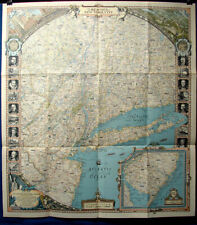
Detailed 1939 The Reaches of New York City National Geographic MapDescription
The pictures show five views of this Detailed 1939 The Reaches of New York City National Geographic Map. The first picture shows the entire map and the others show many details in the four corners. There is much that could be said about this map. In the top left there are city buildings and skyscrapers, trains, subway, Automobiles, buses, people, and more. At the top are cherubs or angels. There is a panoramic birds eye scenic view at the top right with houses, ships, boats, water, a bridge, subway, people and more. The bottom left has the Statue of Liberty and a child with a cornucopia of food. The bottom right has an inset of Southern New Jersey. There are also cruise ships or ocean liners and sailing ships.
The map has all of New York City and parts of New York State, New Jersey, Massachusetts, Pennsylvania, and Connecticut. On the two sides there are many images including: The National Geographic Society logo, New York City emblem, U.S. President Grover Cleveland, U.S. President Theodore Roosevelt, West Point Academy, The 1939 - 1940 New York World's Fair Trylon & Perisphere, Rockefeller Center Building, Hudson Palisades, Atlantic City Boardwalk, Columbia University, Montauk Light House, the Brooklyn Bridge, Henry Hudson, Thomas Edison, Robert Fulton, Alexander Hamilton, Nathan Hale, J. A. Roebling, and Eli Whitney. The map is marked on the bottom as follows:
COPYRIGHT 1939 BY THE NATIONAL GEOGRAPHIC SOCIETY, WASHINGTON, D.C.
PRINTED BY A. HOEN & CO., LITHOGRAPHERS, BALITMORE, MD., U.S.A.
The map measures 26-1/2'' x 29''. It is in mint condition with folds as pictured.
This would make a great collector gift or addition to any New York City, N.Y.C., National Geographic, Map, History, Historic, World's Fair, Transportation, Paper or Ephemera collection!
tpnc#e723