In this day and age of high-tec flightsimming, it seems pilots have become accustomed to and also quite cosy with the large quantity of navigation applications available to them. When the two words “Paper” and “Charts” are innocently converged in the same sentence, many people immediately begin to question the ethics associated – “why bother with such products as paper charts when I have all sorts of advanced flight plan programmes at my disposal?”. Well, while its true that flight management programmes are becoming an increasingly popular method of planning for those who like to ‘turn and burn’, paper charts are simply the pinnacle of navigation realism.
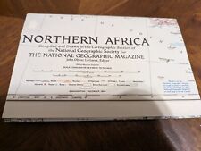
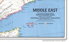
Desktop Wings is a small company, based in Dublin, Pennsylvania, USA, which offers a variety of paper charts for flightsimming use, including the set for Europe/N.Africa and the Middle East which is the topic for this review.
![]()


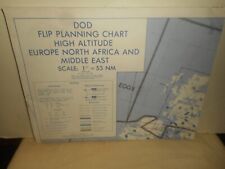
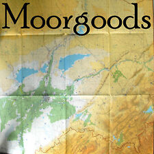
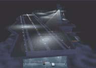
To put simply, the chart package comes complete with 16 High-Altitude jet-route colour charts, printed back to back on 8 sheets of folded quality paper. Hold on a sec, I hear you mutter, is that it? No dear reader, there is a lot more to that, a LOT more…
The charts are nicely folded into a small handy sheet with the name, date and number of the chart in hand at the front. Also on the front is a very handy colour map of Europe, North Africa and the Middle East with rectangular boxes over each region showing you which chart is for each. The chart itself, when you look at it, distinctly reminds you of the ones airline pilots use, pretty much because airline pilots use them! When you open out the charts, you are presented with a large and (what seems a) daunting amount of information – one of the main highlights of these charts – Detail.
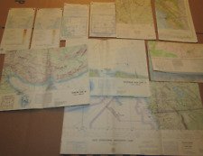
The sight is quite extraordinary. A complex pattern of hight-altitude airways, intersections and VORs, contained within airspace clearly marked with light blue lines of different shape, superimposed over green boundaries (or coastlines) of the country’s they represent. At first glance, one cannot help but utter some kind of exclamation of astonishment – primarily “Wow!”. These charts are simply amazing. Each airway is clearly marked, joining different intersections and VORs which themselves are clearly marked in high resolution print. Each waypoint is given GPS co-ordinates aswell as radials and headings from one to the next. Airspace and special routes are also stated, with correct frequencies and NOTAMS, such as airspace opening hours. All in easy on the eye colours such as light blue, light green, light brown etc. This information becomes quite cluttered in busy airspace (such as over London), yet the high resolution prevents any overlaps and the information can always be clearly seen. For anyone unfamiliar with any terms in the chart itself, there is a handy Legend to the back of the the front map we talked about earlier. Also, at the top and bottom of the chart frame there are several scales to use to work out the distance of your route with a ruler.
The quality of the paper is nice, it has a smooth feel to it, and is quite light. This lightness however is the cause to getting the paper torn easily. This should not impose too much of a problem though, as with proper care these charts will stay with you for life.
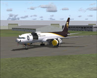
Using the charts with flight simulator is a novel experience. As you begin to plan your flight, you really get a sense of professionalism; you “feel” like a real pilot. After all, these charts were designed for real aviation and used by real pilots. For one of my flights, I flew a 767 from Dublin to Frankfurt without using FSNav or another flightplanner. I simply plotted my flightpan on the charts required with a ruler and pencil, entered the airways and intersections into the FMC and I was off. I monitored my flight with the charts (stuck to the front of my flight yoke) and noted each waypoint I crossed. On landing at Frankfurt, the sense of professionalism and achievement gained was a neat feeling.
So why use these charts? After all you could do the exact same with an on-screen planner. Well, not really. These paper charts contain more information, and are really convenient. If you want to plan a flight or check a flight route, no need to fire up your pc or FS, just look at the charts. Using monitors can also be difficult to plan a flight, with small on screen charts you have to keep moving, or it covers the panel altogether. You could also argue that CD-based charts are similar or easier, but just consider how many pages and ink cartridges you would need to use to print out a large chart, which could be in low resolution with smudges. You wouldn’t get the realism you get from using high-quality paper charts. Even the feel of them in your hand is realistic, its something to grasp and use physically like real pilots. Honestly, you just cannot beat quality paper charts such as these from Desktop Wings.
Those pilots among you who generally prefere to “kick the tyres and light the fires” will get less enjoyment out of these charts, but anyone who is the least bit serious about a realistic flight experience should not be without them. I have been truely impressed and DW deserve a round of applause for providing such a quality product.
To put simply – If you’re into enroute charts, you’re into Desktop Wings.
A big thank you for Alfred and Bebe Poor of DW who were very friendly in their assistance.
These charts are available for $20 +S/H from www.desktopwings.com